Adventure Journal


Sunday 27 January 2008

Borer’s Falls Hike

Sunday, January 27 - 2008
13:00 – 16:35
Start: 13:10
Roads: Dry / Clear
Visibility: 24km
Temp: +1C
Area: Borer's Falls
Vehicle: Black Sunfire
Weather: Overcast, Cold, No Wind
Trail Conditions: Snow Covered
Hikers: Tori, Wolf, Chuck, Merlin, Morgana
Plan: Hike to the waterfall
GPS: 43.29347 x -79.93674

13:00 Arrive in Hamilton as we originally wanted to goto rattlesnake park. We found a closer park using google maps!

13:10 Hit the trails. Lots of other people around, we want to get into the gorge and explore.

13:20 We found a gentle slope downhill to the bottom of the gorge. During our descent I started to go fast, and saw a nice large treetrunk infront of me. I put up hands up to grab a hold of the tree to stop my descent and to my surprise and the laughter of Chuck and Tori – the tree snapped and fell over! I toppled down the hill screaming but did not fall over. We then continued on.

13:40 Merlin and Morgana found a raccoon in a tree stump. We ripped the dogs off the tree and grabbed some photos. Nearby was a sign stating "Bruce Trail Campsite – CLOSED This sign must have been here for a great many years as they stopped camping on the trail decades ago.

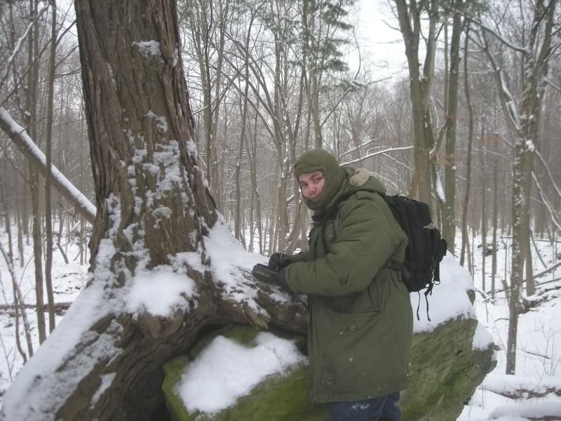
14:20 We started to the ravine where the waterfall was located to find a wonderful evergreen – possibly a cedar growing through a big rock. We took some photos and chuck noticed some blood on the ground. Merlin was bleeding from his front paw. We stopped for a bit to bandage-up Merlins left front paw using some duct tape and a dollar-store dickie that Chuck had. We normally don't carry first aid kits, but our hikes have become increasingly difficult as of late. We just proved the need for one.

15:02 We stopped for a rest a fair distance from the waterfall location. On one side was a sheer rock wall, on the other, the partially frozen stream.

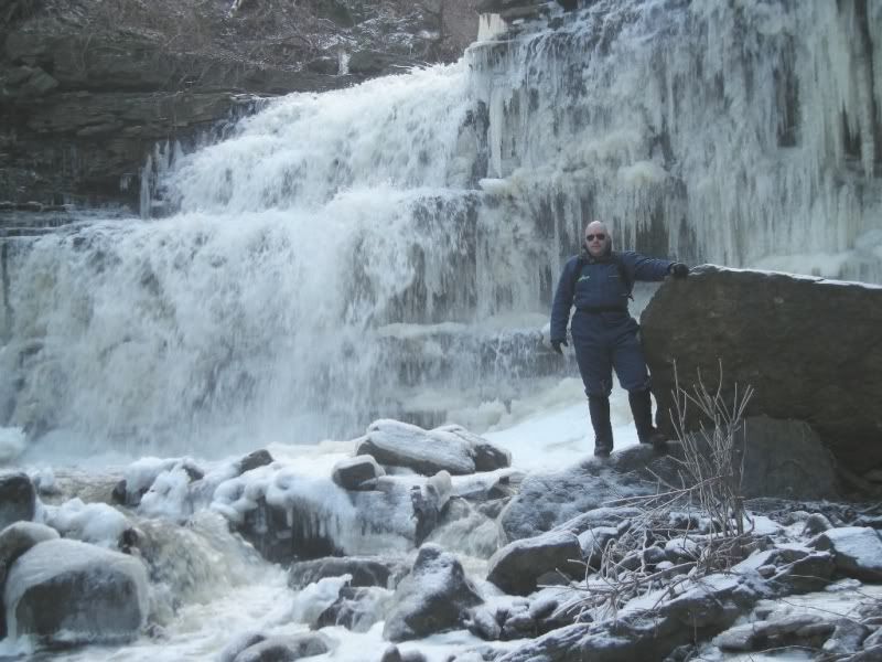
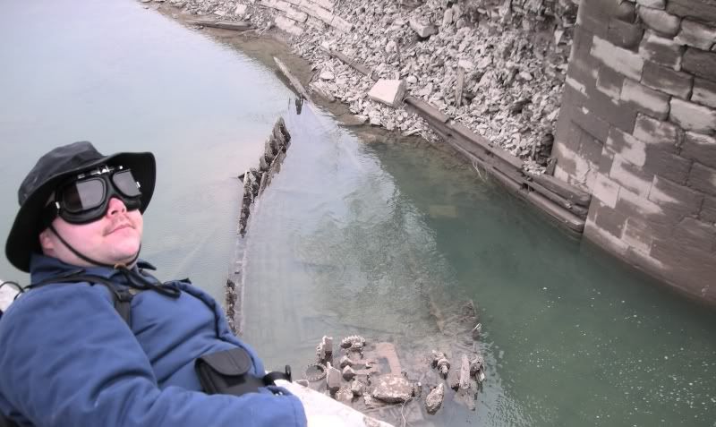
15:47 We arrived at the waterfall with some difficulty. There was a lot of debris scattered about near the waterfall in the form of old antique pots and pans as well as large bails of old fencing. It's very beautiful here. We found a nylon white rope stretching from the top of the canyon to the bottom. We could have done this in 1/8th the time but it was fun either way. We took some photos and relaxed then headed back out. The rock face had some great ice formations to photograph and Tori stayed closer to the rim of the canyon. During our photos – Tori let out a bone chilling scream!

Chuck and I raced to see what the issue was only to find nothing wrong but the dogs whining was really bothering her. Chuck and I returned to the ice formation to grab some more photos.

16:10 We made the rather challenging climb up the steep rock face with some old beat up and questionable looking ropes.

16:20 We made it to the top of the small canyon and made the brief treck back to the car on the road. During the hike we could hear the cries of a hawk overhead.

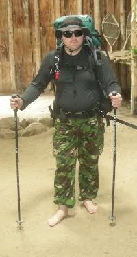
As usual I wore my faded glory boots, goretex gaiters, military underwear, blue coveralls, parka, ski-mask and new military hydration pack and my black WWII Reproduction goggles – which fogged up right away and were useless. I need to buy some proper ones for these harsh environments.

16:32 We arrived at the car, changed Merlins bandages and examined the gaping wound in his hand and removed our gear to head for home.

It was a great hike and a great waterfall with amazing ice formations. The best part about this spot was a challenging hike down into the canyon and even more challenging to reach the area. That meant for us, there was a greater degree of desolation.

Saturday 19 January 2008

Beamer Conservation Area WaterFall

Sunday, January 19 - 2008
12:00 – 16:30
Start: 12:00
Roads: Dry / Clear
Visibility: 24km
Temp: -9C
Area: Beamer Conservation Area
Vehicle: Lada Niva
Weather: Overcast, Cold
Trail Conditions: Frozen Ground
Hikers: Tori, Wolf, Chuck, Merlin, Morgana
Plan: Hike to the waterfall
GPS: 43.19 x 79.58

A few months ago, Chuck was driving along a road in Grimsby, Ontario by our dive instructor Eric's place and came across a large waterfall. He took Tori and I there once and we always meant to go back. Today I took the day off work to relax as my job work me steady Saturdays at the moment. We got all bundled up to hike in the area. This was the first this is the first time we have had our Niva back in over a month as the repairs were extensive and all the parts had to be shipped to Canada from Hungary.

12:00 We arrived at the small parking lot at the top of the escarpment to find 8 cars in the lot. There was barely a spot for us. We parked the Niva and I put on my blue hiking suit, now embellished with my "Wolfmaan" logo overtop my camouflage pants and brown button-up shirt, gaiters Faded Glory boots, parka, ski-mask and sun glasses. Tori put on her black pants, rubber boots, parka, sweaters, and ski-mask and we hit the stone packed trails. Right away we came across a few hikers with a big black lab that Morgana snarled at. The lab had a muzzel on. We continued up the trail to find a small loop of gravel-packed stone with a large black lookout tower with steps leading up to it. At the far southern corner was a small trail map on a sign. We looked at it and Chuck noticed a small quarry listed on the map he had not seen the last time he was here.

12:18 We headed down th e stone packed trail until we came to a small beaten down path through the snow heading eastbound off to the distance. We followed the path, figuring it might lead to the old quarry.

12:24 We started to see a small depression in the escarpment, partially flooded but frozen over. There were quite a few young Birch trees and such growing in the rock where we could get right to the edge of the cliffs and observe the town of Grimsby below. We could even see Toronto across the lake. We took a few photos and headed up to a different trail we found – part of the Bruce Trail, taking it Southbound until we came to a large deck constructed of metal, wood, and concrete with a bench for sitting. This was one of the observation decks installed by the park for people to sit, relax, and take in the view.

13:00 We came to the beginning of a set of blue blazes indicating a Bruce Trail Side-Trail, and found ourselves descending some stairs made of packed stone with wooden sides carved into the top of the escarpment. Eventually we came across a hiker with black trousers, green jacket and white beard with a hat and gloves on. He said he loved Jack Russell Terriers.

13:!4 We decided to split off the eastern facing trail and take the plunge into the untreaded bush and towards the small, partially frozen river flowing east to west below us and have a closer look, and possibly follow it westbound to the waterfall. The waterfall was an unusual snot green color.

13:25 We started walking along the creek-bed towards the west. The low water levels made it possible to hike. The terrain was difficult but fairly quick to navigate and keep away from the frozen water.

13:40 I stopped to notice t hat the foam of the river had actually frozen in small piles! I scooped some of the frozen foam up with my hatch gloves to find it had a frosty, power like consistency. I brushed a little to my face to find it was indeed frozen. It felt very strange and was fascinating to see.

14:31 We arrived at the waterfall to see it was of course partially frozen. Our new hydration packs with military camelbak pouches had frozen up and we could not get any water to come through the hoses or bite valves.

14:44 We took a few photos of the waterfall and decided with frozen water tubes, -9C outside temperatures, we should head back to the Niva as quick as we could.

15:01 Chuck suggested an alternative to the long hike back – straight up the canyon walls! We reluctantly agreed and started the long climb back up the steep, canyon wall. About ¾ of the way to the top, Thirst got the better of me and I perched myself on a tree, opened my pack and exposed the warm hydration pack. I opened the fill cap and had a drink. The water went everywhere but at least I was able to drink.

15:22 We arrived at the top of the canyon to meet-up with a piece of the blue trail, to follow back to the trail head and then back to the Niva. This was the first hike with our new black hydration packs. It was very frustrating how they froze up on the trail. Even chucks Gatorade ended up with ice crystals in it.

16:30 We arrived back at the Niva and headed for home to warm up.

Sunday 13 January 2008

Inland Shipwreck Found!!

Sunday, January 13 - 2008
10:30 – 13:45
Start: 10:20
Roads: Dry / Clear
Visibility: 24km
Temp: -4C
Area: Welland Canal
Vehicle: Black Sunfire
Weather: Overcast, Cold
Trail Conditions: Wet & Muddy
Hikers: Tori, Wolf, Chuck
Plan: Find Land-Locked Shipwreck

A bit of background on this shipwreck. A few years ago there was a re-print of an article in a magazine called "Niagara This Week" by Chris Irwin, which portrayed a photo of a shipwreck. The article states he was driving down an old road in Thorold he did not know existed and ended up at the Old Seaway property. Irwin followed the road past the old streetcar abutments, and eventually found a shipwreck in the Old Welland Canal. No other useful information was found. The St. Lawrence Seaway has closed a lot of the roads in the area and the details in the article were sketchy at best.

At one point, Tori and I visited the Lock 3 museum in an attempt to find details about this wreck but there were none. All attempts to contact the author of the article failed.

Tori, Chuck and I made several excursions to this site to reveal negative results. However until now, the canal system was full of water. This time of year, however, the canal is empty and we have the opportunities to explore the area with significantly less danger and very low or non-existent water levels. Hopefully we will find the wreck today.

10:30 – We started our journey by checking out the old streetcar abutments by Walker Industries. The area was sadly still flooded and we decided to head for the west corner Lakeview Cemetery and began at the far west corner. We parked Chucks black sunfire and geared up and headed towards the now empty flood pond behind Walker Industries. We were pleasantly surprised to see the water levels were very low at the old hydro facility, and the flood pond almost completely drained.

10:50 We came to the edge of the old lock to see half a dozen cars piled up, now rusted from their time spent underwater. The old locks were spectacular to see. We followed the locks to find a small pond area that was now also empty. Tori with her rubber bots on was the only one able to venture into that area and explore. She noted that in some areas, a thick, black, oil like sludge was sighted. Evidence of the contamination of this area from the ships passing through here for over a hundred years. Tori did notice some old pilings from docks which once stood in the area as well as some antique bottles.

11:30 We ended up at the base of an old lock right, near an overturned car. We stopped for a few photographs then proceeded to climb up the side of the lock and follow it along to the other end. To our surprise: there we found the shipwreck.

Formerly sitting in about 10m of water, the ship sat facing south east in about 1-2m of water. We could see all the parts such as the prop-shaft, boiler cradle (boiler long removed), decking, and the shape of the wreck. We got some photos and decided to go around to the other side of the lock for closer inspection. The ship sat at a 45 degree angle across the locks, almost blocking them completely.

12:00 We arrived at the base of the old lock to find the shipwreck looking back at us. We grabbed a few more photos and observed the wreck. The main deck looks to have fallen into the hull, albeit still intact. Chuck found a rubber boot, but it was a modern rubber boot and we decided to leave it on the bottom. The wind was cold and blew directly towards us. Sadly the frigid waters prevented us from getting a closer look at the wreck. Perhaps in a drysuit or wetsuit before the canal is refilled.

12:35 We began the hike back to the car.

12:40 We felt a shift in the wind and now could smell the odor from the nearby dump at Walker Industries and as well the rotting kelp from the water as most of the area was now not submersed. We crossed back across the drained pond and Chuck stopped to investigate some of the old bee bottle necks Tori had seen earlier, but most of them were relatively new bottles.

Chuck was happy that today he was able to set foot on that island off in the distance which he wanted to explore in summer when the entire area was covered in 5-10m of water.

13:00 we arrived at the base of another large lock set, normally full to the top with flowing water, now subdued from the lack of flow. We stood on the old piled up cars and grabbed some photos and examined the vehicles. Some were fairly new with disc breaks and front-wheel drive motors, others were very, very old with a huge v8 engine in it. After some more photos we climbed back out of the lock and headed back towards the car.

13:45 We arrived back at the car, parked in the cemetery and headed for home. Wolf wore his faded glory boots, gaiters, blue insulated jumpsuit, black hat and goggles. Tori wore her rubber boots, black pants, purple turtleneck with beige hat and winter parka. Chuck wore his winter boots, black nylon pants and blue bingo-hall shirt with beige britches jacket. We were all very excited about the find. We need to find more about this wreck, how it got here, were it was build, and how old it is. Sadly we can only safely get to this site during the winter when the canal area is empty. We could go in the area in scuba but it may be very bad visibility and dangerous current in this location.

I would guess by the location of the shipwreck that it may have drifted to this location over the years and got stuck somehow where it currently lay. What a fantastic find!